
Travel Arizona - Antelope Canyon & Lake Powell Photography Workshops
Hello all! it's Rachel. I am so happy that you have stopped by my Page, Arizona Workshop page that includes excursions into Upper & Lower Antelope Canyon, the Horseshoe Bend State Park, into the narrows of Lake Powell, Rainbow Bridge, Lees's Ferry, Glen Canyon Dam and the Rattlesnake Slot Canyon. I look forward to telling you about my photographic workshops. First, they are as much tours of the area that we are visiting as they are workshops. I have spent thousands of hours driving down every country and National Park Service road possible in my effort to uncover the most stunning landscape and cultural sites possible for our excursions. All summer workshops, although visiting similar destinations, will have uniquely designed routes giving all those who desire to attend one (or more) spring, summer and fall excursions here in Arizona the opportunity to experience a variety of planned and unplanned stops throughout each of my photographic workshops; each distinctively different from one another. I was born and raised in Arizona. I have enjoyed living on both the east and west coasts in my lifetime; and where I am as home as I've ever been living in the mountains of Colorado at this point in my life, Arizona will always be 'home.' The history and geology of northern Arizona is so unique and begs to be photographed. Arizona is known for their dramatic rich-colored sunrises and sunsets. The canyons that have been formed are the result of millions of years of flash floods and weather events. The Glen Canyon Dam, which rises an impressive 710 feet above the Colorado River (built in 1963) provides essential water storage and electricity for much of the southwestern United States. The Dam is a wonder to photograph both day and night, as it is lit throughout the night. Lake Powell took 17 years to fill; the lake has a storage capacity of 27,000,000 making it the second largest manmade reservoir in the country. Many do not know this, but Rainbow Bridge is the largest natural bridge in the entire world. The bridge spans 475 feet across, is 42 feet wide at the top of the arch and is 42 feet thick and 33 feet wide. It is a wonder and is a very sacred place to the local Navajo Nation Indian Tribe
Below you will find sample itineraries and a list of my tours scheduled for the 2016 Page Arizona Workshops. Aside from the group tour dates listed below, private single day, weekend, and week long tours are available for photographers ranging from beginning hobbyist to professional level enthusiasts. Each photographer who joins me for a "group" tour, will receive one-on-one as well as group instruction each day of the tour. Technique building exercises for all levels skill levels are incorporated into each and every stop.
______________________________________________________________________________________________________________
May Below the scheduled itineraries give you an idea of what you can expect on a typical day. i pending, routes and stops may change. Each workshop is $950.00 (not including cost of hotels, meals, and (1) professionally guided tour in the slot canyons). I have set up discounts for hotels and some of the meals. The tour fee covers our rental van, gas, park fees, photographic tutorials, water, snacks and two post processing Photoshop tutorials.
Day One
Thursday: Scenic Drive to Page Arizona
Numerous photographic stops along the way:
-
Sunrise at Watson Lake in Prescott
-
Historic Jerome
-
Sedona
-
Oak Creek Canyon
-
Overnight stay 3 nights, Page AZ
Day Two
Sunrise at Watson Lake in Prescott
through Upper Antelope Slot Canyon,
Owl Slot Canyon, and Rattlesnake Slot
CanyonNavajo BridgeHorseshoe Bend
-
Upper Antelope Slot Canyon,
-
Owl Slot Canyon,
-
and Rattlesnake Slot Canyons
-
Day Three
-
Antelope Ridge Marina
-
Navajo Canyon
-
Labyrinth Canyon
-
Face Canyon / Gunsight Butte
-
Crossing of the Fathers
-
Padre Butte / Castle Rock
-
Horseshoe Bend at Sunset
-
Overnight Page, AZ
Day Four
-
Lake Powell Overview
-
Glen Canyon Dam
-
Navajo Bridge
-
Montezuma's Castle
-
Sunset Crater


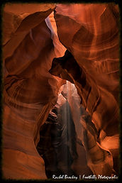

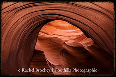


A sample of images we'll capture during this tour

This first grouping of images are from the beautiful~
Lower Antelope Slot Canyon in Page, Arizona.
The Navajo name for Lower Antelope Canyon is Hasdeztwazi or "Spiral Rock Arches." Many years ago, herds of Pronghorn Antelope roamed freely in and around the canyon, which explains the English name for this canyon.
This incredible canyon has been created over many thousands of years by the relentless forces of water and wind, slowly carving and sculpting the sandstone into forms, textures, and shapes which we observe today. The views in Lower Antelope Canyon change constantly as the sun moves across the sky, filtering lights softly across the stone walls. These ever-moving sun angles bounce light back and forth across the narrow canyon's walls, creating a dazzling display of color, light, and shadow.
There are two entry points into this slot canyon, respectively named the lower and upper entry points; I prefer the lower because "KEN'S TOURS, my personal favorite tour company for the canyon, allows photographers to roam FREELY for two full hours, without the crowding that typically happens during a guided tour. The tours are organized and move brisky through the narrow canyon, so shooting around them is pretty easy. Antelope Canyon is only a few miles from the marinas of beautiful Lake Powell and a short distance from the world renowned majestic Rainbow Bridge Natural Arch and Horseshoe Bend Monuments. The upper and lower entries are only a 1/2 mile from one another. You must make arrangements to enter the upper (last time I checked).. the lower requires no reservation.
Antelope Canyon is located near Page on Navajo Nation land, just outside Glen Canyon National Recreation Area and close to AZ 98 a few miles east of town (at milepost 299).

Despite improved warning and safety systems, the risks of injuries from flash floods still exist in the canyon. Entry is heavily regulated, and is only allowed with proper permits and tour company ID tegs.. most tours take about an hour, photographers are extended 2 full hours.

Antelope Canyon is visited exclusively through guided tours, in part because rains during monsoon season can quickly flood the canyon. Rain does not have to fall on or near the Antelope Canyon slots for flash floods to whip through, as rain falling dozens of miles away 'upstream' of the canyons can funnel into them with little prior notice.


Prior to the installation of metal stairways, visiting the canyon required climbing along pre-installed ladders in certain areas. Even following the installation of stairways, it is a more difficult hike than Upper Antelope—it is longer, narrower in spots, and even footing is not available in all areas. At the end, the climb out requires several flights of stairs.
Despite these limitations, Lower Antelope Canyon draws a considerable number of photographers, though casual sightseers are much less common there than in Upper.
The lower canyon is in the shape of a "V" and shallower than the Upper Antelope. Lighting is better in the early hours and late afternoon.
Lower and Upper Antelope Canyon's are located just a few miles from Page Arizona is LeChee, Arizona on Navajo Indian Land.
I have full color and monochrome images available of every captures. I professionally print each image, individually, none are sent through "batch printing" style. I inspect every print before it is shipped for quality and color balance. All images are shipped UPS or Fed-Ex with a certified shipping label for ease in tracking and 100% of all purchases have a money back guarantee. Greeting cards, and a full array of print sizes are available. Prints are avaiilable in luster, glicee for framing and stretched gallery canvas with hangs independent of a frame. Images are guaranteed to have the vibrance, color and clarity you see on the screen.


